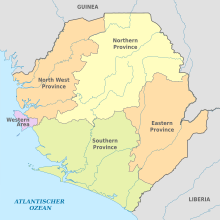
Provinces of Sierra Leone
Appearance

 |
|---|
|
|
Sierra Leone is divided into four provinces (until 2017, three) and one Western Area; these are further divided into 16 districts (previously 14), and the districts are further divided into 190 (previously 149) chiefdoms.[1]
Provinces and areas
[edit]| Province/Area name | Capital | Area | Population (2015 census) | Population Density |
|---|---|---|---|---|
| Eastern Province | Kenema | 15,553 km2 (6,005 sq mi) | 1,641,012 | 110/km2 (270/sq mi) |
| Northern Province[a] | Makeni | TBD | 2,502,865 | 70/km2 (180/sq mi) |
| Southern Province | Bo | 19,694 km2 (7,604 sq mi) | 1,438,572 | 73/km2 (190/sq mi) |
| North West Province[b] | Port Loko | TBD | 1,162,065 | 70/km2 (180/sq mi) |
| Western Area | Freetown | 557 km2 (215 sq mi) | 1,493,252 | 2,700/km2 (6,900/sq mi) |
See also
[edit]References
[edit]- ^ "Sierra Leone unveils new geographical map". Africa Review. Retrieved 2018-02-01.
Notes
[edit]External links
[edit] Media related to Provinces of Sierra Leone at Wikimedia Commons
